A park with no way in. Everyone was working the funding. The problem was 1,200 feet of geometry.
A private industrial developer. A state highway corridor. An access point that wasn't going to get permitted.
01. The Situation
The Client
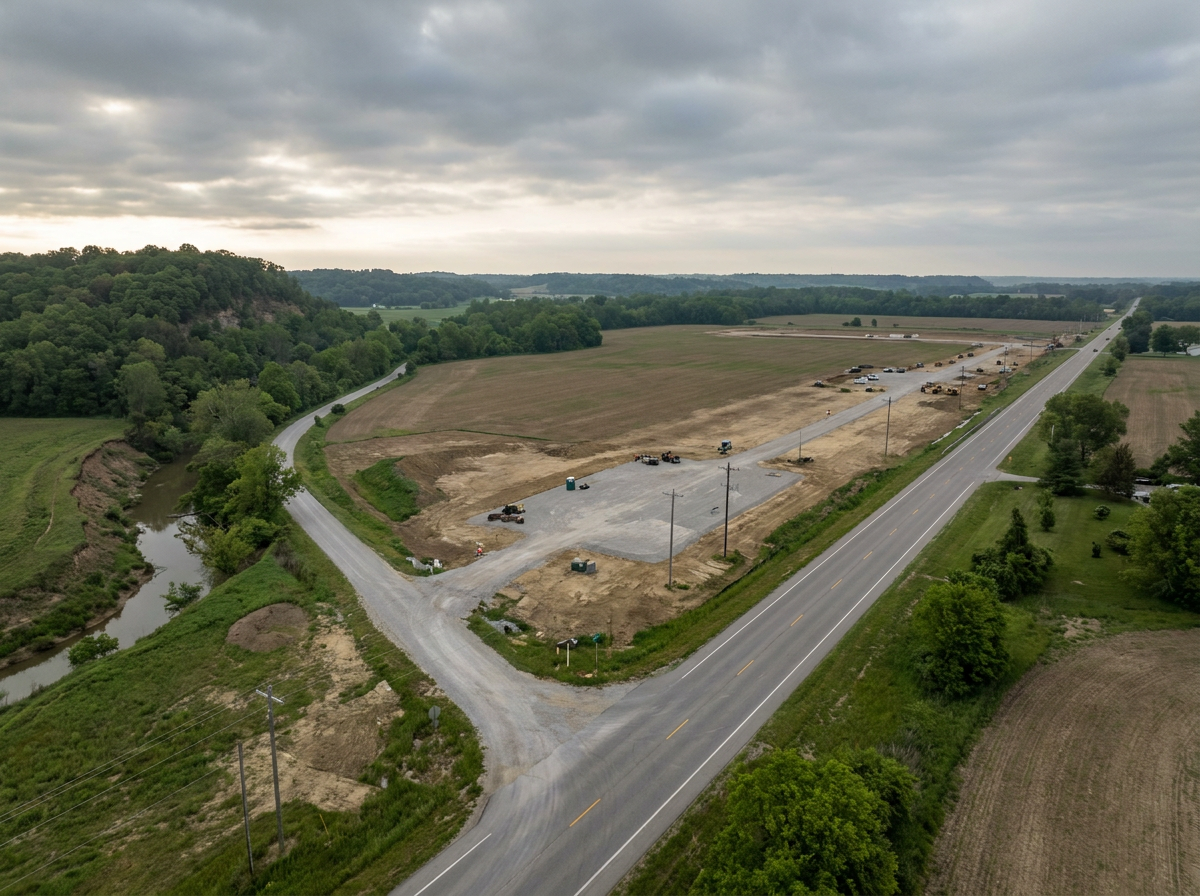
A private industrial developer assembling a multi-tenant park on a state highway corridor in southern Indiana. The site had acreage, utilities within reach, and a motivated anchor user ready to move.
It had no viable connection to the state highway that runs past its front door. Without an approved access point, the park is not a park. It is farmland with a brochure.
The Problem
The assumed solution was an existing county lane. Everyone involved had organized around it: the anchor user assumed it was the only option, a state agency had been asked to push it, and the private parties were already working the funding question.
The lane was a dead end in both directions. Adjacent landowners were prepared to stop it, and the intersection geometry the state DOT would have to approve was not obviously approvable — a 4% grade at the proposed intersection, a stop condition on a downhill run, sight-distance limits, a bluff and a creek pinching the available right-of-way, and a hard 1,200-foot minimum between intersections.
Meanwhile the anchor user was quietly talking to other landowners, other parties were working the same corridor, and the clock the client was operating against was not its own.
The Core Ask
The client engaged us at what most groups treat as step four. The first three steps — what can the DOT actually permit, where on the corridor does the geometry work, and what does the delivery structure trigger procedurally — had never been run. That was the work.
02. Why Access Road Projects Stall
Before scoping the work, we mapped the structural patterns that sink these projects. The failures are consistent across corridors and jurisdictions.
They are treated as an engineering problem.
The engineering is the easy part. Access is an entitlement problem wearing an engineering costume — DOT approval, right-of-way, adjacent landowners, and procedural exposure. Treating it as geometry is how groups spend months designing a road that was never going to get permitted.
The alignment gets locked before the DOT is asked.
Once a group has organized around a route, every subsequent dollar defends the route rather than tests it. The permit is the constraint, and the permit is the last thing anyone checks. By the time the DOT says no, the political capital and the funding relationships are already committed to the wrong alignment.
The money comes before the geometry.
You cannot fund a road no agency will permit. Funding strategy that runs ahead of design feasibility is expensive optimism. The state, local, and private stack is only meaningful when it is attached to an alignment that can actually be built — in this development cycle, not the next one.
“You cannot fund a road no agency will permit. Geometry first, procedure second, money third — every group that reverses that order pays for the privilege.”
03. The Approach — Five Phases
Direct engagement with the state DOT district before any concept was drawn. What we surfaced was geometric, not political: a 4% grade at the proposed intersection, a stop condition on a downhill run, sight-distance limits, a bluff and a creek pinching the available right-of-way, and a hard 1,200-foot minimum between intersections.
Rather than defending the assumed alignment, we scoped a second one. The DOT was cautiously supportive of a new industrial access road if the intersection issue on the grade could be solved — which reframed the entire question from "how do we win the lane?" to "where on this corridor is there a permittable intersection?" A green-T configuration was tested against alternate frontage, along with the feasibility of a land trade to reach it.
A review of federal environmental review exposure. If the DOT built the improvement, the project inherited a federal review process and an archaeological-potential risk that could have added years. If the private party performed the site work and conveyed the completed intersection right-of-way, that trigger was avoidable. This was the single largest schedule variable in the project and it was not on anyone's list.
Scoped and issued a traffic study RFP so the intersection case would be made with data the DOT could act on — not with assertions from interested parties. The client controls the evidence base, not the counterparty.
Mapped the state, local and private funding architecture against the alignment options, and kept the DOT, the state economic development agency, the county, the anchor user, and the affected landowners working from one set of facts.
04. The Critical Path
Sequence, Reordered
The client engaged us at what most groups treat as step four. The first three had never been run.
The Procedural Step Is the Schedule
The question of who builds the intersection looked administrative. It was not. The public path carried federal environmental review and archaeological exposure that a private build-and-convey structure avoided entirely. Nobody at the table had flagged it. That single variable was the difference between a road in this development cycle and a road in the next one.
Why Most Groups Start at Step Four
Funding is visible, urgent, and politically tractable. Geometry and procedure are technical, slow, and unglamorous. So groups work what they can move — and discover the real constraints after they've committed to an alignment they can't permit. The order is not incidental. It is the problem.
05. The Three Moves That Made the Difference
We Asked the DOT What It Could Approve Before Anyone Drew a Line
One meeting reframed the project. The agency was not opposed to industrial access — it was constrained by a grade, a stop condition, and a spacing standard. Constraints stated plainly are solvable. Assumed opposition is not. Every hour spent designing the wrong alignment is an hour that could have been spent finding the right one.
We Treated the Default Alignment as a Hypothesis, Not a Plan
The lane everyone had organized around carried both political opposition and geometric risk. Testing a second alignment cost a fraction of what defending the first one would have — and it moved the DOT from unwilling to conditionally supportive. The sunk cost in the original route was real; the case for continuing to defend it was not.
We Found the Schedule Trap Before It Closed
The question of who builds the intersection looked administrative. It was not: the public path carried federal environmental review and archaeological exposure that a private build-and-convey structure avoided entirely. Nobody at the table had flagged it. It was the difference between a road in this development cycle and a road in the next one. That finding came from a procedural risk review that cost a fraction of what the delay would have.
06. The Deliverable Set
Delivered on a five-month fixed-fee engagement scoped tightly to the access matter — no incentive work, no scope creep, no hourly meter.
DOT Constraint Assessment
What the agency can actually approve on this corridor, and why. The constraint map that makes the rest of the work possible.
Alternative Alignment Analysis
Whether a permittable intersection exists outside the assumed route. Green-T configuration, alternate frontage, and land trade feasibility.
Procedural Risk Memo
Which delivery structure triggers federal environmental review — and which avoids it. The single largest schedule variable in the project.
Traffic Study RFP
The evidence base, procured on the client's terms rather than a counterparty's. Data the DOT can act on, not assertions from interested parties.
Funding Options Analysis
The state, local and private stack, mapped to each alignment scenario. Funding strategy attached to something that can actually be permitted.
Stakeholder Engagement
DOT, state agency, county, anchor user and landowners working from one set of facts. One point of contact, one version of the project.
07. What the Client Received
A Second Path Where There Had Been One
An alternative alignment with the DOT's conditional support, replacing a single route that carried both landowner opposition and unresolved geometry.
Years of Schedule Risk Removed
A delivery structure that keeps the intersection improvement out of federal environmental review — identified before the client committed to a path that would have inherited it.
Control of the Evidence
A traffic study procured and scoped by the client, so the case to the DOT rests on data rather than on whoever shouted loudest at the corridor meeting.
A Funding Strategy Attached to Something Real
Funding options mapped against alignments that can actually be permitted — instead of a financing plan for a road that was never going to get built.
If your site's value depends on infrastructure you do not control, the agency's constraints are your project plan — whether or not you have read them.
Find out what can be permitted before you spend a dollar defending what cannot. The cheapest engineering in any development is the meeting you have before the engineering starts. That is the work.
Geometry First. Then the Rest.
Whether you are assembling a site, working an access problem, or trying to understand what your corridor can actually support — this is where the conversation starts.
Start a Conversation →Client identity withheld by agreement. Parties, parcels, counterparties, negotiated terms and internal deliberations are excluded from this summary; technical constraints are described as communicated by the reviewing agency. Engagement scope, sequence and deliverables are described as executed.